publications
2026
-
 Any Model, Any Place, Any Time: Get Remote Sensing Foundation Model Embeddings On DemandDingqi Ye, Daniel Kiv, Wei Hu, and 2 more authors2026
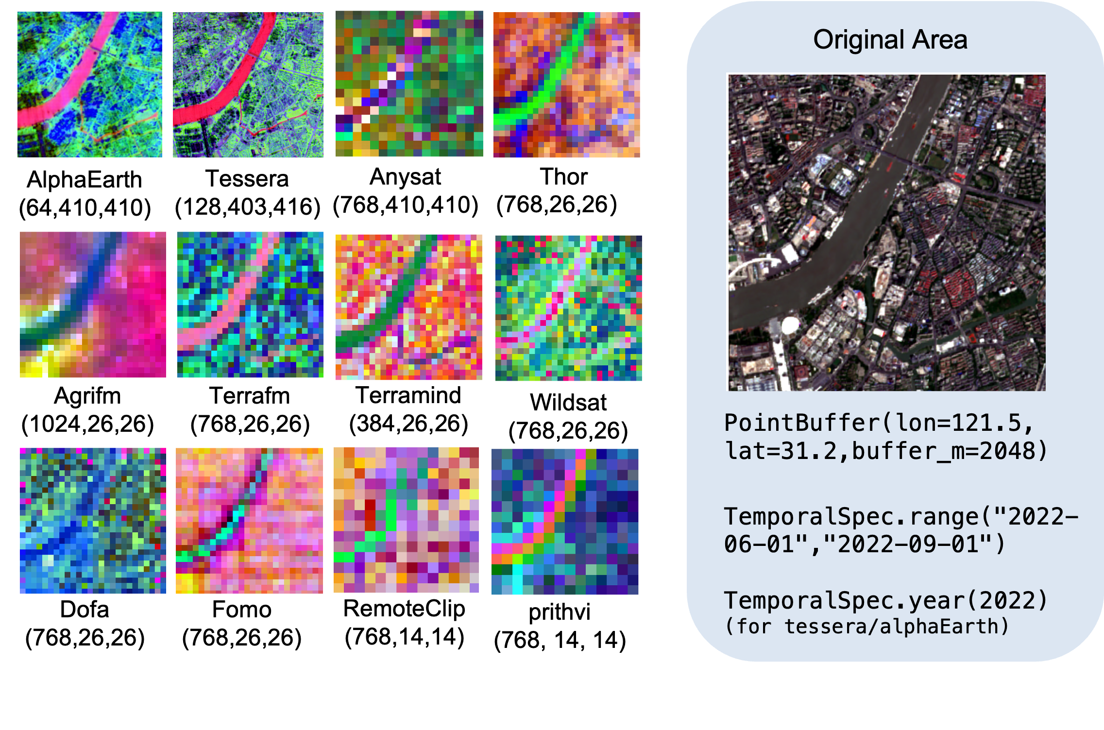
The remote sensing community is witnessing a rapid growth of foundation models, which provide powerful embeddings for a wide range of downstream tasks. However, practical adoption and fair comparison remain challenging due to substantial heterogeneity in model release formats, platforms and interfaces, and input data specifications. These inconsistencies significantly increase the cost of obtaining, using, and benchmarking embeddings across models. To address this issue, we propose rs-embed, a Python library that offers a unified, region of interst (ROI) centric interface: with a single line of code, users can retrieve embeddings from any supported model for any location and any time range. The library also provides efficient batch processing to enable large-scale embedding generation and evaluation. The code is available at: https:// github.com/ cybergis/ rs-embed
-
 MultiCube-RAG for Multi-hop Question AnsweringJimeng Shi, Wei Hu, Runchu Tian, and 8 more authorsarXiv preprint arXiv:2602.15898, 2026
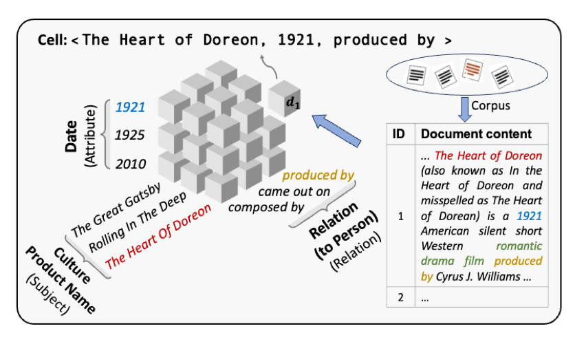
Multi-hop question answering (QA) necessitates multi-step reasoning and retrieval across interconnected subjects, attributes, and relations. Existing retrieval-augmented generation (RAG) methods struggle to capture these structural semantics accurately, resulting in suboptimal performance. Graph-based RAGs structure such information in graphs, but the resulting graphs are often noisy and computationally expensive. Moreover, most methods rely on single-step retrieval, neglecting the need for multi-hop reasoning processes. Recent training-based approaches attempt to incentivize the large language models (LLMs) for iterative reasoning and retrieval, but their training processes are prone to unstable convergence and high computational overhead. To address these limitations, we devise an ontology-based cube structure with multiple and orthogonal dimensions to model structural subjects, attributes, and relations. Built on the cube structure, we propose MultiCube-RAG, a training-free method consisting of multiple cubes for multi-step reasoning and retrieval. Each cube specializes in modeling a class of subjects, so that MultiCube-RAG flexibly selects the most suitable cubes to acquire the relevant knowledge precisely. To enhance the query-based reasoning and retrieval, our method decomposes a complex multi-hop query into a set of simple subqueries along cube dimensions and conquers each of them sequentially. Experiments on four multi-hop QA datasets show that MultiCube-RAG improves response accuracy by 8.9% over the average performance of various baselines. Notably, we also demonstrate that our method performs with greater efficiency and inherent explainability.
2025
-
 SFNet: Fusion of Spatial and Frequency-Domain Features for Remote Sensing Image Forgery DetectionJi Qi, Xinchang Zhang, Dingqi Ye*, and 4 more authorsIEEE Journal of Selected Topics in Applied Earth Observations and Remote Sensing, 2025*Corresponding author
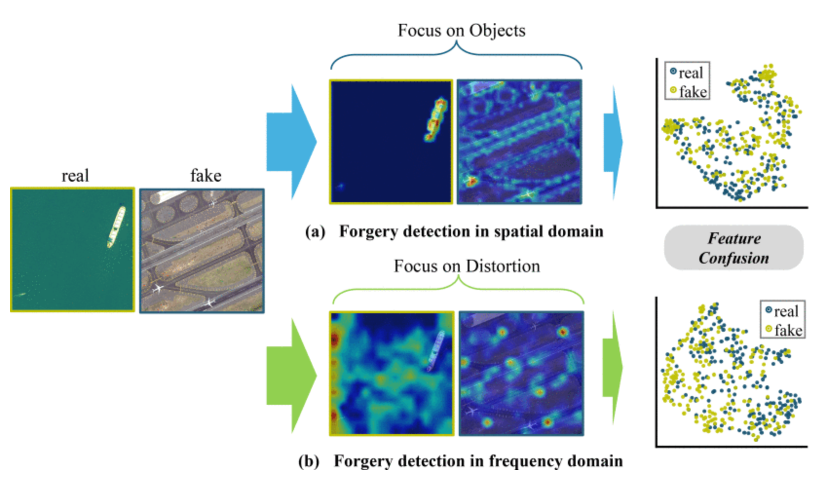
The rapid advancement of generative artificial intelligence is producing fake remote sensing imagery (RSI) that is increasingly difficult to detect, potentially leading to erroneous intelligence, fake news, and even conspiracy theories. Existing forgery detection methods typically rely on single visual features to capture predefined artifacts, such as spatial-domain cues to detect forged objects like roads or buildings in RSI, or frequency-domain features to identify artifacts from upsampling operations in adversarial generative networks (GANs). However, the nature of artifacts can significantly differ depending on geographic terrain, land cover types, or specific features within the RSI. Moreover, these complex artifacts evolve as generative models become more sophisticated. In short, overreliance on a single visual cue makes existing forgery detectors struggle to generalize across diverse remote sensing data. This article proposed a novel forgery detection framework called SFNet, designed to identify fake images in diverse remote sensing data by leveraging spatial and frequency domain features. Specifically, to obtain rich and comprehensive visual information, SFNet employs two independent feature extractors to capture spatial and frequency domain features from input RSIs. To fully utilize the complementary domain features, the domain feature mapping module and the hybrid domain feature refinement module of SFNet are designed to successively align and fuse the multidomain features while suppressing redundant information. Experiments on three datasets show that SFNet achieves an accuracy improvement of 4%–15.18% over the state-of-the-art RS forgery detection methods and exhibits robust generalization capabilities.
2024
-
 OBSUM: An object-based spatial unmixing model for spatiotemporal fusion of remote sensing imagesHoucai Guo, Dingqi Ye, Hanzeyu Xu, and 1 more authorRemote Sensing of Environment, 2024
Spatiotemporal fusion aims to improve both the spatial and temporal resolution of remote sensing images, thus facilitating time-series analysis at a fine spatial scale. However, there are several important issues that limit the application of current spatiotemporal fusion methods. First, most spatiotemporal fusion methods are based on pixel-level computation, which neglects the valuable shape information of ground objects. Moreover, many existing methods cannot accurately retrieve strong temporal changes between the available high-resolution image at base date and the predicted one. This study proposes an Object-Based Spatial Unmixing Model (OBSUM), which incorporates object-based image analysis and spatial unmixing, to overcome the two abovementioned problems. OBSUM consists of one preprocessing step and three fusion steps, i.e., object-level unmixing, object-level residual compensation, and pixel-level residual compensation. The performance of OBSUM was compared with seven representative spatiotemporal fusion methods at two agricultural sites. The experimental results demonstrated that OBSUM outperformed other methods in terms of both accuracy indices and visual effects over time-series. Furthermore, OBSUM also achieved satisfactory results in crop progress monitoring and crop mapping. Therefore, it has great potential to generate accurate and high-resolution time-series observations for supporting various remote sensing applications.
-
 Adaptive Multiscale Slimming Network Learning for Remote Sensing Image Feature ExtractionDingqi Ye, Jian Peng, Wang Guo, and 1 more authorIEEE Transactions on Geoscience and Remote Sensing, 2024
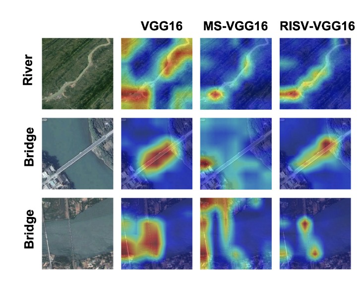
Effective feature representation is pivotal in numerous remote sensing image (RSI) interpretation tasks. Notably, a distinct attribute of RSIs is their inclination toward multiscale feature dependence. Previous research predominantly focuses on designing intricate and complex networks or modules to encapsulate rich multiscale features. However, these approaches compromise on either the model’s compactness or its representational efficacy, thereby constraining the practical deployment of remote sensing technologies, particularly in limited-capacity environments like small-scale devices or on-orbit satellites. In this study, we explore the problem of how to augment the diversity of encoded features while avoiding heavy parameter scale growth in deep convolutional neural networks (CNNs). We proposed an adaptive multiscale framework RISV which presents two key features: 1) rich scale information: during training, RISV decomposes each convolutional layer into various-sized convolutions, extracting multiscale characteristics; and 2) small model volume: RISV incorporates a differentiable elect layer after each convolutional layer, adaptively calculating and polarizing channel importance during learning. After training, the added convolution kernel and the significant channels selected by the elect layer will be linearly equivalent merged, minimizing the impact of pruning on the model’s feature extraction capability. Different from traditional model slimming, it focused on a slimmed-down network while enhancing the representation of multiscale features in RSIs. Versatile and adaptable across various model frameworks like VGG and ResNet. Experimental results demonstrate that our methodology not only preserves accuracy across standard skeletal frameworks but also attains a compression ratio exceeding 80%, surpassing the baseline by an average of 40%. Furthermore, the application of GradCAM on the NWPU dataset reveals our method’s proficiency in acquiring detailed and accurate subject information from RSIs. The source code can be available at https://github.com/GeoX-Lab/RISV.
2023
-
 Lifelong learning with cycle memory networksJian Peng, Dingqi Ye, Bo Tang, and 3 more authorsIEEE Transactions on Neural Networks and Learning Systems, 2023
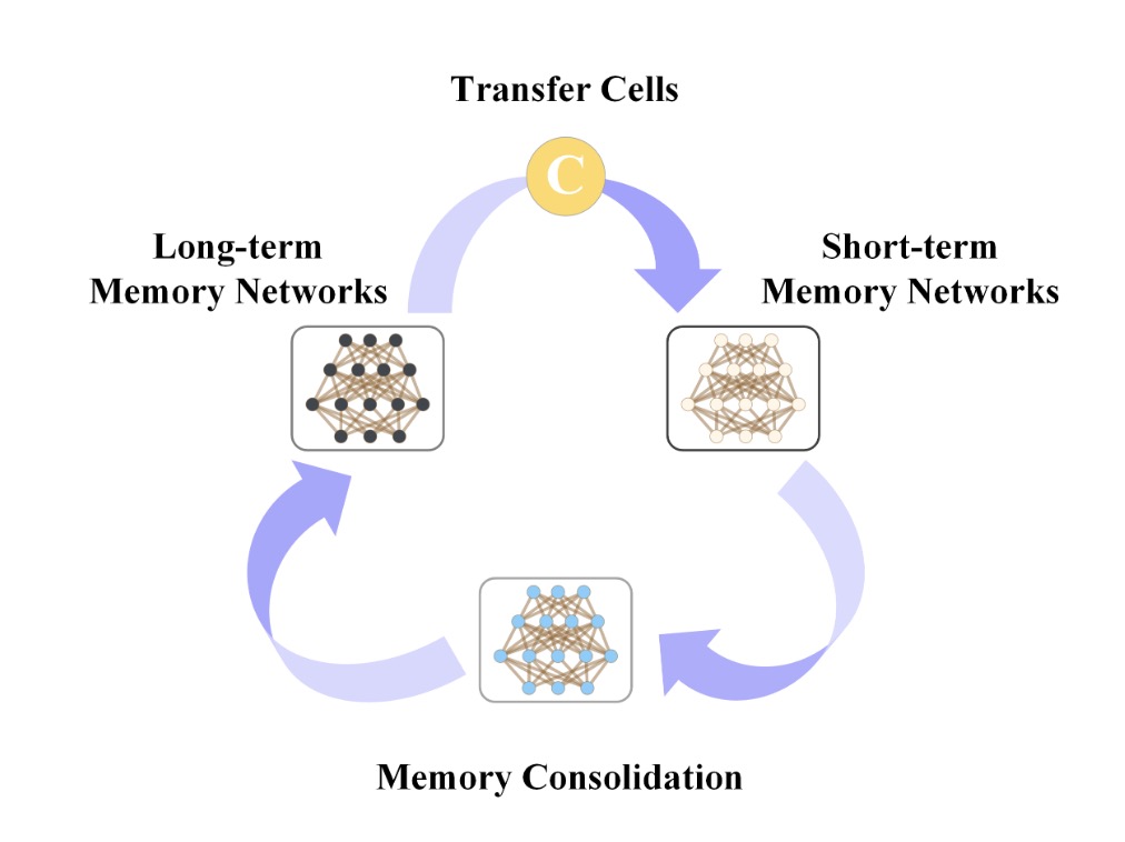
Learning from a sequence of tasks for a lifetime is essential for an agent toward artificial general intelligence. Despite the explosion of this research field in recent years, most work focuses on the well-known catastrophic forgetting issue. In contrast, this work aims to explore knowledge-transferable lifelong learning without storing historical data and significant additional computational overhead. We demonstrate that existing data-free frameworks, including regularization-based single-network and structure-based multinetwork frameworks, face a fundamental issue of lifelong learning, named anterograde forgetting, i.e., preserving and transferring memory may inhibit the learning of new knowledge. We attribute it to the fact that the learning network capacity decreases while memorizing historical knowledge and conceptual confusion between the irrelevant old knowledge and the current task. Inspired by the complementary learning theory in neuroscience, we endow artificial neural networks with the ability to continuously learn without forgetting while recalling historical knowledge to facilitate learning new knowledge. Specifically, this work proposes a general framework named cycle memory networks (CMNs). The CMN consists of two individual memory networks to store short- and long-term memories separately to avoid capacity shrinkage and a transfer cell between them. It enables knowledge transfer from the long-term to the short-term memory network to mitigate conceptual confusion. In addition, the memory consolidation mechanism integrates short-term knowledge into the long-term memory network for knowledge accumulation. We demonstrate that the CMN can effectively address the anterograde forgetting on several task-related, task-conflict, class-incremental, and cross-domain benchmarks. Furthermore, we provide extensive ablation studies to verify each framework component. The source codes are available at: https://github.com/GeoX-Lab/CMN.
-
 Continual learning for remote sensing image scene classification with prompt learningLing Zhao, Linrui Xu, Li Zhao, and 5 more authorsIEEE Geoscience and Remote Sensing Letters, 2023
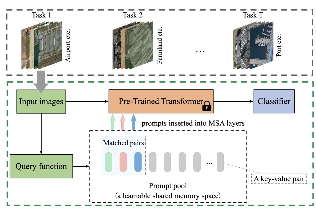
Overcoming catastrophic forgetting is a key difficulty for remote sensing image (RSI) classification in open-world applications. The core of this problem lies in the ability of RSI scene classification models to adapt to the changing environment and maintain the learned knowledge while continually learning new knowledge. Mainstream replay-based approaches overcome catastrophic forgetting by reenacting and retracing past experiences in the process of learning new data. However, such approaches rely heavily on the storage of historical data, and the recent rise of new paradigms based on prompt learning offers a new perspective of using only task-related “instructions” (i.e., prompts) to guide the model’s continual learning and reasoning. Therein, the task knowledge encoded by the prompt improves the model’s ability to overcome forgetting while reducing the amount of data and model parameters required by traditional data-driven approaches. Therefore, we propose a continual learning method based on prompt learning for RSI classification. We systematically analyze and reveal the potential of prompt learning for continual learning of RSI classification. Experiments on three publicly available remote sensing datasets show that prompt learning significantly outperforms two comparable methods on 3, 6, and 9 tasks, with an average accuracy (ACC) improvement of approximately 43%. Performance improvements of 4%–6% were achieved when compared with advanced prototype network methods. We found that prompt-generation strategies and prompt-related components significantly affect performance: (1) prompt-generation strategies are strongly correlated with the model’s performance in overcoming catastrophic forgetting; (2) prompt-related components are correlated with RSIs of different scales. The new paradigm of prompt learning potentially provides a new idea for the continual learning problem of RSI classification.
2022
-
 Better memorization, better recall: A lifelong learning framework for remote sensing image scene classificationDingqi Ye, Jian Peng, Haifeng Li, and 1 more authorIEEE Transactions on Geoscience and Remote Sensing, 2022
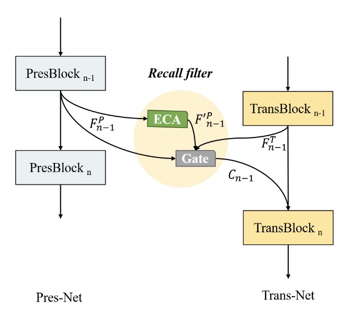
To infer unknown remote sensing scenarios, most existing technologies use a supervised learning paradigm to train deep neural network (DNN) models on closed datasets. This paradigm faces challenges such as highly spatiotemporal variants and ever-changing scale-heterogeneous remote sensing scenarios. Additionally, DNN models cannot scale to new scenarios. Lifelong learning is an effective solution to these problems. Current lifelong learning approaches focus on overcoming the catastrophic forgetting issue (i.e., a successive increase in heterogeneous remote sensing scenes causes models to forget historical scenes) while ignoring the knowledge recall issue (i.e., how to facilitate the learning of new scenes by recalling historical experiences), which is a significant problem. This article proposes a lifelong learning framework called asymmetric collaborative network (SCN) for lifelong remote sensing image (RSI) classification. This framework consists of two structurally distinct networks: a preserving network (Pres-Net) and a transient network (Trans-Net), which imitate the long- and short-term memory processes in the brain, respectively. Moreover, this framework is based on two synergistic knowledge transfer mechanisms: triple distillation and prior feature fusion. The triple distillation mechanism enables knowledge persistence from Trans-Net to Pres-Net to achieve better memorization; the prior feature fusion mechanism enables knowledge transfer from Pres-Net to Trans-Net to achieve better recall. Experiments on three open datasets demonstrate the effectiveness of SCN for three-, six-, and nine-task-length learning. The idea of asymmetric separation networks and the synergistic strategy proposed in this article are expected to provide new solutions to the translatability of the classification of RSIs in real-world scenarios. The source codes are available at https://github.com/GeoX-Lab/SCN.